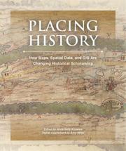
Overview
- Format
- Book
- Published
- Redlands, Calif. : ESRI Press, 2008
- Edition
- First edition
- Contents
-
GIS and history / Anne Kelly Knowles
Creating a GIS for this history of China / Peter K. Bol
Teaching with GIS / Robert Churchill and Amy Hillier
Scaling the dust bowl / Geoff Cunfer
"A map is just a bad graph" : why spatial statistics are important in historical GIS / Ian N. Gregory
Mapping husbandry in Concord: GIS as a tool for environmental history / Brian Donahue
Combining space and time: new potential for temporal GIS / Michael F. Goodchild
New windows on the Peutinger map of the Roman World / Richard J. A. Talbert and Tom Elliott
History and GIS: implications for the discipline / David J. Bodenhamer
What could Lee see at Gettysburg? / Anne Kelly Knowles. with Will Roush, Caitrin Abshere, Lucas Farrell, Andrew Feinberg, Thom Humber, Garriott Kuzzy, and Charlie Wirene
Conclusion: an agenda for historical GIS / Anne Kelly Knowles, Amy Hillier, and Roberta Balstad. - Notes
-
Papers presented at a conference held at the Newberry Library in Chicago in March 2004.
Includes bibliographical references (pages 277-292) and index.
GIS and history / Anne Kelly Knowles -- Creating a GIS for this history of China / Peter K. Bol -- Teaching with GIS / Robert Churchill and Amy Hillier -- Scaling the dust bowl / Geoff Cunfer -- "A map is just a bad graph" : why spatial statistics are important in historical GIS / Ian N. Gregory -- Mapping husbandry in Concord: GIS as a tool for environmental history / Brian Donahue -- Combining space and time: new potential for temporal GIS / Michael F. Goodchild -- New windows on the Peutinger map of the Roman World / Richard J. A. Talbert and Tom Elliott -- History and GIS: implications for the discipline / David J. Bodenhamer -- What could Lee see at Gettysburg? / Anne Kelly Knowles. with Will Roush, Caitrin Abshere, Lucas Farrell, Andrew Feinberg, Thom Humber, Garriott Kuzzy, and Charlie Wirene -- Conclusion: an agenda for historical GIS / Anne Kelly Knowles, Amy Hillier, and Roberta Balstad.
CD-ROM in pocket on inside back cover.
Physical Details
- Language
- English
- ISBN
- 9781589480131
1589480139 - Physical Description
- xx, 313 pages : illustrations (some color), maps (some color) ; 23 cm + 1 CD-ROM (4 3/4 in.)
Keywords & Subjects
- Record last modified:
- 2024-06-21 18:37:00
- This page:
- https://collections.ushmm.org/search/catalog/bib150326
Additional Resources
Librarian ViewDownload & Licensing
- Terms of Use
- This record is not digitized and cannot be downloaded online.
In-Person Research
- Requires Research Visit
- Plan a Research Visit
- Check Nearby Libraries
-
Request in Shapell Center Reading Room
Bowie, MD


